The chronicle of Daniel Boone’s 1769 pioneering excursion into the
interior of Kentucky is, literally, the stuff of legends. One could argue that
without that journey and exploration the Boone saga would not exist, for it was
his two-year wilderness odyssey which positioned and prepared him to lead the
Transylvania assemblage to Boonesborough six years later. Absent those
exploits, Boone would have remained just another hunter pushing the frontier.
One key aspect of the trip, indubitably the first item on the group’s
agenda, was to find a suitable location for their base camp. It needed to be
close to a water supply, near the hunting grounds, and convenient to game
trails, but not completely out in the open. Boone found an agreeable site,
close by to several salt licks where their prey congregated; it could make for
leisurely hunting. For several months they used this camp, until a change in
the party’s organization and circumstances dictated otherwise. Determining
exactly where this camp was, though, has proven troublesome until now.
When it comes to Boone, separating fact from fiction, myth from truth, can be a
daunting task. The Daniel Boone of copious popular histories has become so
ingrained in the public mind that divorcing his actual deeds from the doubtful
tales risks accusations of intent to diminish his accomplishments and
remarkable exploits. As one biographer says, “the facts come inextricably
entwined with the legend.”
Another issue arising within any Boone-related study is the often-contradictory
information concerning even the more plausible, mundane and accepted events.
This happens most frequently due to the simple lack of solid facts supporting
the details. One writer will understandably fill the void with an opinion or
theory while the next proffers different particulars. That is the core
problem—we often just do not know with any degree of certainty.
Consequently, finding a solid nugget of Boone data, especially when it concerns
a stated-to-be-unknown subject, is, indeed, most welcome. In this instance the
nugget of data is a land entry and survey; the subject is the whereabouts of
Boone’s 1769 storied base camp—his Station Camp.
Searching
for the camp
The whereabouts of Boone’s station camp, while confidently, albeit
vaguely, located on Station Camp Creek by practically all students of Boone,
has never before been placed with any degree of researched confidence. Lyman
Draper realized this while attempting to pen his Boone biography in the
mid-1850s and lamented that Daniel Bryan had not been asked specifically about
the camp’s location when Bryan was interviewed in 1844. Draper concluded,
“it can probably never be determined with more precision than here
stated.”
The “here stated” position was simply “on the waters of Station
Camp Creek,” as Bryan and Samuel Boone had indicated, likely near the Red
Lick Fork. Draper pointed out that a Red River placement was clearly
incorrect.
The issue weighed on Draper’s mind, as he again broached the subject in
the early 1880s. Elihu Benton, a resident of Estill County, replied to
Draper’s questions.
 |
In answer to your inquiry about Station Camp Creek in this county, and
Daniel Boone’s camp on that creek - I will state that I am only 52 years
old, and know nothing of my own knowledge - it is only hearsay. I am more or
less acquainted with that creek and all its forks and branches. I was born on
the Red Lick Fork of that creek, about 2 1/2 or 3 miles from the main creek,
Feb. 20, 1832. |
|
Benton asked around about the camp and later replied to Draper: “I find
the oldest settlers differ about the old camps and whether by Indians or
whites, or by Daniel Boone. I have tried to see as many men, the oldest
settlers, as I could.”
Throughout the correspondence with Benton and his neighbors, various locations
of camps are mentioned on Station Camp proper and on Red Lick Fork. M.R. Benton
may have been speaking for everyone when he said, “I never knew where
Boone’s Fort was on Station Camp Creek in Estill County, Ky.”
Following Draper, writers positioned the camp on main Station Camp Creek,
sometimes offering that it was in proximity to Red Lick Creek.
Perhaps, as Draper suggested, Bryan knew the camp’s location. It may have
been common knowledge among many of the early residents, or at least among
Boone’s hunting peers. Regardless, one person who definitely did know was
Anthony Bledsoe. And he was kind enough to tell us—in a somewhat obscure
way.
Finding
the camp
Land entries, particularly those from 1779 and 1780, are oftentimes fascinating
and revealing glimpses into the geography of Kentucky as the first great wave
of settlement broke over the landscape. Entrants would use whatever prominent
geographical feature presented itself—a settlement, a creek, a road,
initials carved into a tree—as a marker to try to secure a tract of land
for later surveying. In theory, the better the land was described in the entry,
the less chance there was of a conflicting claim being successfully produced
later.
Anthony Bledsoe, who, along with his brothers Isaac and Abraham, may have taken
part in the 1769 “long hunt” with James Knox, Henry Scaggs and
others, identified his 11 May 1780 claim in terms which a hunter would surely
recognize: “Anthony Bledsoe enters 1000 acres on Station Camp Creek where
the waters Running out of the Blue lick Join those Running from the Red lick
extending up in the forks of the said 2 creeks so as to include Boones old
Station camp.”
Before taking a closer look at Bledsoe’s land, the first obvious question
to address is: Was this camp the station camp? Of course, we have no
corroborating statement made by Boone or his compatriots which would
definitively state that Boone’s camp was on the land Bledsoe entered.
However, unless one wishes to argue that Boone had multiple station camps south
of the Kentucky River, we are left to accept Bledsoe’s entry as
worded—the implication clearly being that Boone had a single station camp
and that the location was generally known at that time. Other camps associated
with Boone, including one on Stinking Creek in Knox County, do not have the
“station” descriptor attached to them.

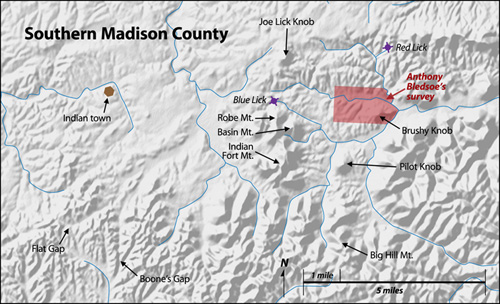
So, where was Bledsoe’s land? Fortunately, the corresponding 1785 survey
is easily placed, primarily due to the watercourses and landmarks
involved. The survey drawing of the
roughly-rectangular, east-west-oriented acreage clearly shows, and labels, the
three streams which comprise the Red Lick Fork of Station Camp Creek—Blue
Lick to the south, Red Lick to the north, Joseph Lick in the center.
The survey is not perfect. Plotting reveals surveying errors typical of the
times and the creeks identified have slightly different modern
names—Joseph Lick is now Joe (or Joe’s) Lick, Bledsoe’s Red Lick
is today’s Gravel Lick, while his Blue Lick is officially called Red Lick.
(The actual Red Lick was in a hollow south of Dreyfus.) As recently as 1950,
maps of the area used the Bledsoe naming scheme. But the locale of the tract is
unmistakable—it is approximately six miles east-northeast of Berea, in
Madison County, north of Pilot Knob, east of Robe Mountain/Basin Mountain.
Brushy Knob is inside the survey’s bounds. Subsequent adjacent surveys
confirm this placement.
In addition, what was once the Blue Lick—sometimes called Boone’s
Blue Lick—lay on the northern flank of Robe Mountain. The “waters running out of the Blue
Lick” would, on a modern map, form Blue Lick Creek, into which runs Horse
Cove Branch. Approximately two miles from the lick, Blue Lick Creek and Cowbell
Creek meet to create Red Lick Creek proper, which then meanders almost 16 miles
before joining main Station Camp Creek a few miles south of Irvine.
Boone’s station camp is not marked on Bledsoe’s survey, so the best
we can do is surmise its location by applying the wording of the entry to the
reality of the area’s topography. Brushy Knob sits immediately west of the
confluence of Bledsoe’s Red and Blue Lick Creeks and its elevation takes
up about 350 acres of the survey. That area can be eliminated if one assumes
the camp was not up on the hill. The implication of the entry’s wording
leads one to believe the camp was not near the confluence, but rather some
distance to the west, in the interior of the survey. Such postulating places
the camp on Joe Lick Fork, perhaps within a 400-acre area centered
approximately at N37.590, W84.193—between Log Cabin Road and Pine Woods
Road. There is a 70-foot-high ridge paralleling Joe Lick Fork on the south
which contains a few shallow hollows or draws. Perhaps the camp was nestled a
few hundred feet from the creek in one of those draws.
Evaluating
the accounts
Locating Boone’s 1769 station camp nearer Blue Lick means it was 12 miles
(measured in a straight line) further west than generally thought. This
distance, while not excessive, has significance in the larger story of
Boone’s trip that year. In fact, it should help resolve some geographical
inconsistencies and contradictions between the various accounts of Boone’s
arrival in the region. A brief look at a select few of those accounts—to
review every one would take up a volume by itself—is warranted.
In order of publication, we shall consider Filson (1784), Draper (1856),
Thwaites (1902), Bakeless (1939), Faragher (1992) and Morgan (2007).
All six accounts have Boone, along with John Findlay, John Stewart, Joseph
Holden, James Mooney and William Cooley,
leaving the Yadkin Valley on 1 May 1769 and making their way to Cumberland Gap
where they picked up the Warriors’ Path and followed it to Flat Lick, in
present-day Knox County.
Filson, writing as Boone, who related the story to him—although it is hard
to know how faithfully it was repeated—devotes only a few lines to the
journey. He says after a long trek westwardly, on June 7 they arrived on the
Red River where Findlay had traded with the Indians (presumably on his trip in
1752). From the “top of an eminence” they viewed the “beautiful
level of Kentucke.” They were distressed, mainly because of the weather
experienced along the trail, and made camp.
Draper, who called Filson’s version “carelessly expressed,”
expanded the story somewhat, based largely on information from Daniel Bryan and
Nathan Boone. Draper has the party taking the maze of connecting game and
Indian trails, which would also be utilized by the Longhunters a month or so
later, from Flat Lick to the head of Roundstone Creek, where they briefly
camped. Alone, while the others worked in the camp and hunted, Boone climbed up
the highest knob—which Draper called Big Hill—and viewed the flat
land for the first time. He then returned to camp and told the others what he
had seen. After resting, the group crossed the Cumberland River-Kentucky River
dividing ridge near Big Hill, steered northeast to Red Lick Creek and followed
that tributary to Station Camp Creek where they established their camp. After
building a suitable shelter, Findlay went off on his own to find the spot where
he had traded with the Indians, taking the Warriors’ Path to the abandoned
town of Eskippakithiki, on Lulbegrud Creek. Findlay returned to camp ten days
after departing, then guided Boone and Stewart to the town, arriving on June 7.
Thwaites relates very little in the way of detail, saying they took the
Warrior’s path from Cumberland Gap to Station Camp Creek, where they made
camp.
Bakeless has the party starting on the Warriors’ Path and ending on the
“headwaters of the west branch of the Rockcastle River.” Reaching
Station Camp Creek by June 7, they made camp. Boone then went off alone,
climbed up Big Hill, viewed the land and returned to camp. Findlay traveled to
Eskippakithiki and back—no time-span mentioned—then took Boone and
Stewart to the town.
Faragher says the group followed the Warriors’ Path through Sand Gap to
Station Camp Creek and made camp two or three miles south of Irvine; he says
Pilot Knob was “nearby.” Boone and Findlay then continued up the Path
to the abandoned Indian town, and, making their way “up the creek that
watered Blue Lick Town, they climbed to a spot known locally as Pilot
View,” where both men beheld the fertile region.
Morgan gets the group to the Rockcastle River area and has them going through
“the low Sand Gap, or Boone’s Gap,” into the Kentucky River
watershed. They made camp at Irvine, then Boone “climbed nearby Pilot
Knob” and viewed the land. Boone and Findlay visited the Indian town on
June 7.
As is immediately obvious, these various accounts disagree on a variety of
issues. And a couple have serious geographic problems. Disappointingly, the two
most recent take the greatest liberties with the area’s geography.
Morgan’s version, in particular, is problematic—Sand Gap and
Boone’s Gap are certainly not the same feature, as he intimates. There are
two Pilot Knobs on modern maps in the region which concern this study—one
is five miles east of Berea, the other is four miles southeast of
Eskippakithiki. Both Morgan and Faragher say Pilot Knob is “nearby”
the town of Irvine; the actual distance to either feature from Irvine is
roughly 15 miles.
For these reasons, and because his information adds little detail to the
discussion, Morgan’s account will not be considered further.
A quick comparison of the accounts reveals this partial list of
readily-apparent contradictions:
- The Warriors’ Path did not go through Sand Gap—at least not if
the community of Sand Gap in Jackson County is intended—as stated by
Faragher. He identifies the gap as lying on the dividing ridge between the
Cumberland and Kentucky River watersheds; perhaps he meant Paint Gap, which is
so situated on the Knox County-Clay County line.
- Bakeless places Big Hill in the immediate vicinity of Station Camp Creek
proper, which is a 15-mile error. He was doing his best to reconcile
Filson’s, Draper’s and Thwaite’s versions, but ignored the
geography.
- A comparison of the five accounts reveals two different travel routes and
viewing-the-land sites. Twaites and Faragher keep the explorers on the
Warriors’ Path until camp is made on main Station Camp Creek, while Draper
and Bakeless have the group utilizing the interconnecting trails leading to the
buffalo road on Roundstone Creek before finding their way to Station Camp
Creek.
- There are also two different viewing-the-land sites. Faragher sets the
vantage point as Pilot View—presumably the northern Pilot Knob nearer
Eskippakithiki. Draper and Bakeless say it
was Big Hill, which could either mean Big Hill Mountain, south of the community
of Big Hill, or the southern Pilot Knob, which overlooks the community of Big
Hill (the two landmarks are only two miles apart).
- Twaites fails to specify the viewing spot; Filson gives neither route nor
view-point location details. Faragher indicates Boone and Findlay both climbed
the viewing height; the others say Boone went alone.
- The dates and details of Findlay’s trip to the abandoned Indian town
vary, with Draper and Bakeless interpreting events given in Filson differently.
In fact, the most important discrepancies come down to the differences between
Filson and Draper. As previously noted, Draper believed Filson’s rendition
was “carelessly expressed.” Draper did not feel comfortable in
dismissing Filson but he had solid information that Boone’s first camp was
south of the Kentucky River, while a later camp was north, nearer the Red
River.
Inspecting
Draper’s version
In retrospect, based on the information Draper accumulated in combination with
what we now know about the location of the camp, Filson’s version seems a
compressed and incomplete timeline of events (although that may not be an
accurate appraisal, as explained later). This is not the proper place to
conduct a discussion of the veracity of Filson’s Narrative, but in this
particular instance a case can be made that Draper gives a more complete and
convincing accounting of the group’s movements, although he may have
shortchanged himself by trying to reconcile his own research with Filson’s
writings.
With that in mind, Draper’s version of events bears closer scrutiny. To
begin, Draper gives Boone’s route as similar to the path he used in 1775
when going to Boonesborough. An involved discussion of the early roads is not
appropriate here; the important issue is that Draper brings Boone up Roundstone
Creek. Suffice it to say that Boone could most certainly have found himself on
Roundstone in 1769 with relative ease. Daniel Bryan seems to have implied Boone
went that way and we know he returned home by using the route.
Other accounts which have Boone traveling entirely on the Warriors’ Path
seem to be the logical product of the desire to create the best route to his
camp, thought to have been on main Station Camp Creek. Even absent Draper’s Roundstone Creek course,
if the camp was not on the creek proper but near the headwaters of Red Lick
Creek, a Warriors’ Path-only route makes much less sense—there is no
reason to postulate Boone leaving main Station Camp Creek, turning up Red Lick
Creek and traveling for an extra day or so, only to have Findlay turn around
and go back down the tributary to pick up the path to Eskippakithiki a few days
later. Had they been so close to the town, they would likely have gone there
first.
The initial problem with Draper’s account materializes with his mention of
Big Hill, as that feature is not on Roundstone Creek proper. Boone would have
had to have left his easily-followed buffalo road and made a significant
eastern detour—more than seven miles—to ascend Big Hill (and he
really would not have climbed up the hill at all, as he would have simply found
himself at the top in the natural course of travel). The only way for Boone to
have reasonably arrived at Big Hill would for him to have followed Clear Creek
to its head. Clear Creek is a tributary of Roundstone, so, technically, the
headwaters of Clear could be termed the headwaters of Roundstone. However,
Boone would not have passed by the mouth of Clear Creek in 1769 and would not
have, at that particular time, known of its existence.
There is also some question as to how much of the flat Bluegrass region Boone
could have seen from the ridgetop. So having Boone at Big Hill does not seem
logical.
Big Hill, at the time Draper was writing, was a prominent locale and an
often-traveled road went through the area. The southern Pilot Knob is near Big
Hill, so it is possible that it is the “eminence” Boone ascended. But
to get to that point from the Roundstone headwaters Boone would have traveled
through some fairly level ground and passed by several other good—and
closer-to-the-trail—vantage points.
It should be noted that a 1949 geologic map
has the area north of Pilot Knob marked as “Big Hill.” Whether this
was a simple labeling error or if the entire area was once considered “Big
Hill” is unclear.
Taking Draper’s account exactly as written, including the temporary camp
and assuming that Boone did not travel several miles before ascending, the
viewing site must have been located near the headwaters of Roundstone Creek.
Depending on the definition of the precise location of those headwaters, we are
left with only two possibilies. The first is the knobby ridgeline above US 25
at Boone’s Gap on the Madison-Rockcastle County line. The second is less
than two miles west, near Flat Gap, where Garrard, Madison and Rockcastle
Counties corner.
Neither height offers a breathtaking view, but Boone would have been able to
spy something of the flatter land beyond.
The remainder of Draper’s description looks to have been devised to get
the main camp on Station Camp Creek proper. Red Lick Creek is the most obvious
route. Of course, since we do not have to
travel so far to the camp, other possibilities appear.
Climbing
the “eminence”
One of the most direct statements in Filson’s account concerns the
location of the camp in relation to the viewing point. Speaking of the height,
he states: “At this place we encamped, and made a shelter to defend us
from the inclement season, and began to hunt and reconnoitre the country.”
This is in conflict with Draper, who has the viewing point and camp separated
by at least a dozen miles.
Locating the camp as we have near Brushy Knob opens up several possibilities
for the “eminence,” as there are four notable and suitable
knobs/hills in the area: Joe Lick Knob; Brushy Knob itself; the aforementioned
Pilot Knob; and Robe Mountain/Basin Mountain/Indian Fort Mountain.
- Brushy Knob fits best with the exact wording in Filson, as the camp could
very well have been on its northern shoulder. It is the shortest of the four in
terms of elevation and offers the poorest view.
- Joe Lick Knob, northwest of the camp, offers a much better view and is a
distinctive feature; it is about two miles from the Bledsoe land.
- Pilot Knob is similar to Joe Lick Knob and about the same distance from
the camp, only to the south.
- The Robe/Basin/Indian Fort complex is a little taller than the others and
can offer an outstanding view, while being a comparable distance from the camp.
Solid arguments could be made in favor of any of the four. But Robe Mountain
has something going for it that the others do not—it would have been the
first one Boone approached as he moved northward and there was very likely a
buffalo road or game trail leading him directly to the Blue Lick at the foot of
the mountain.
With the camp located on the upper reaches of Red Lick Creek, the prospect of
the viewing point being near the camp is much more probable. It may also have
been easy for Boone to have used the same elevated vantage to scout out a
likely camping spot or two. In fact, it is almost impossible to imagine Boone
and the others not climbing atop Robe Mountain or Joe Lick Knob to peer across
the landscape, since both prominences were conspicuous, accessible and
convenient to their camp.
Resolving
differences
A crucial characteristic of Filson’s version is that, read literally, not
only did Boone view and camp in the same area, but Findlay also had traded with
the Indians nearby. Draper, and most other biographers, clearly dismiss this
triple-event scenario.
There is a potential way out of this quandry. It is possible that Findlay
traded with the Indians at a post other than Eskippakithiki, or traded with
them in multiple places. There was at least one small Indian town or settlement
in the Berea area—on Walnut Meadow Branch of Paint Lick Creek, no more
than a couple of thousand feet west of Exit 77 on Interstate 75. This presumed town was less than five miles west
of the Blue Lick and a path connected the lick to the town area. If Findlay traded with the Indians here after
visiting Eskippakithiki, then events could have happened essentially as
described by Filson, with Red Lick Creek substituted for the Red River.
Otherwise, we are left with Draper’s solution: Filson, in retelling
Boone’s story, mixed up some details and compressed incidents which
occurred at two different locations into a single event.
One other specific but contradictory detail given in the various accounts is
the date, June 7. Filson has that date assigned to all three
events—arrival at the town, viewing the flat land and making camp. Draper
has June 7 only as when Findlay, Boone and Stewart visited Eskippakithiki, with
a minimum of ten days passing between making camp and the visit. Bakeless has
camp being made on that date, with the town visit happening later.
Analyzing travel rates yields inconclusive results in regard to the June 7
date. In 1775, it took Boone’s group approximately 15 days to get from
Sycamore Shoals to the general area of the Blue Lick, while Richard
Henderson’s entourage needed about 25 days. Allowing for the extra
distance from the Yadkin Valley to Sycamore Shoals, and taking into
consideration the slightly different routes used, similarly-paced journeys from
the Yadkin Valley to the Blue Lick would have taken approximately 20 and 31
days, respectively—a difference in traveling rates of 9 miles per day as
opposed to almost 14.
One would think that Boone’s smaller 1769 party traveled faster than
Henderson’s larger group six years later, although perhaps not as quickly
as did Boone that same year because by that time he knew where he was going,
even though they were taking time to mark the trail. A reasonable estimate
would place Boone, Findlay, et al, at the camping site sometime during the last
week of May.
Findlay took ten days to find Eskippakithiki and return to camp, according to
Draper. Surely Findlay rested for a day before leading Boone and Stewart back
out. Covering the approximately 38 miles between the camp and town would have
taken the trio two or three days—the way should have been relatively easy
and by then Findlay knew where he was going. Counting backward 14 days from
June 7 sets the camp-making date as no later than May 24. Even allowing an
extra couple of days would leave them a minimum of 22 days to travel from the
Yakin Valley to the Blue Lick. Thus, Draper’s sequence of events will fit
into the timeline.
This does not mean Filson’s date is incorrect or unreasonable, as the
party may have had an unusually slow journey picking their way through the maze
of trails and dealing with inclement weather. So the June 7 date cannot be used
in strong support of or in opposition to either account.
Concluding
the journey
In the end, we are left with two versions of Boone’s arrival into the
interior of Kentucky.
One follows Filson’s wording very closely—the obvious difference
being his Red River situating of events—with the traditional placements of
the Indian town where Findlay traded being near Walnut Meadows (not
Eskippakithiki) and the camp being in its new-found location a couple of miles
east of the Blue Lick (not on either Station Camp Creek proper or the Red
River). The “eminence” where Boone first viewed the fertile land of
Kentucky’s interior could be a number of places—Boone’s Gap,
Flat Gap, Robe Mountain, Joe Lick Knob, Pilot Knob or Brushy Knob.
The other version would be similar to Draper’s, with the major departure
being the camp’s location east of the Blue Lick instead of on main Station
Camp Creek. In this case, the viewing point would very likely have been either
Boone's Gap or Robe Mountain, although the other potential locations also
remain possibilities, and Findlay (and later Boone and Stewart) would have
followed Red Lick Creek down to Station Camp Creek, then taken the
Warriors’ Path to Eskippakithiki.
Which version is the most reasonable depends in large part on how much trust
one places in Filson’s retelling of Boone’s story—and on the
likelihood of Findlay previously trading with the Indians at Walnut Meadows. It
must be pointed out that there is nothing in the record which solidly addresses
the existence of a town near Walnut Meadows in the 1752 time-frame when Findlay
was actively trading with the Indians, only that a small outpost or town once
existed in the area at some point in history.
One final item worthy of mention is the “Squire Boone rock” on
display in the Madison County courthouse. This man-sized, limestone slab,
inscribed “1770 Squire Boone,” was found at the base of Robe
Mountain/Basin Mountain, either on the northern side a few thousand feet from
the Blue Lick or on the eastern side in Horse Cave Hollow. As is the case with
many Boone-related artifacts, the authenticity of this autograph has been
debated over the years. Legend has it that Squire cut his name into the rock
upon returning from Virginia in the spring of 1770 to let Daniel know he had
returned safely and to mark a cache of much-needed supplies.
Perhaps knowledge that Boone’s station camp was nearby adds an extra sense
of legitimacy to the monument.
Notes:
|